
* My apologies in advance: this essay contains many inadequacies, as it is a first draft. When I have more time, I will fix everything. Think of this essay as more of a proposal than a proof.
_________
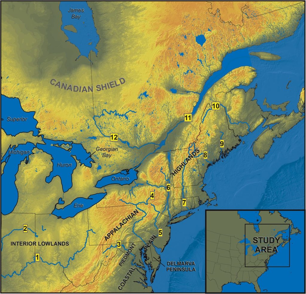
In my view, the Nephites were located in the north-eastern United States. This view isn’t based on any dreams, but just my personal opinion.
Specifically, my theory is based on a view that the geography of this area was different in a specific way:
I believe that during the time of the Nephites, Lake Ontario drained normally down the St. Lawrence river. However, the other lakes: Lake Erie, lake Huron, and Lake Superior all actually drained in a different direction – probably north towards the Hudson bay, though I am not totally sure.
Thus, there was no river connecting Lake Erie and Lake Ontario (today, the Niagara River connects them). This gap would therefore have formed the “narrow passage” leading to the land northward. So, the Nephites lived around New England but could cross this narrow passage between the lakes into Canada, the land northwards. Seeing the great many lakes in Canada, this all aligns with Helaman 3:4, which describes the land northwards as being full of many large bodies of water. And just to emphasize, there really would have been no other land route across to Canada beyond this section between Lake Erie and Lake Ontario, as the often several mile wide St. Lawrence river connects Lake Ontario all the way to the Atlantic, and (since I believe all of the Great Lakes besides Ontario used to be connected) going around the other direction would require a truly epic journey going all the way around Lake Superior.
So how did the geology change? Well, per the Book of Mormon, during the three days of darkness prior to Christ’s death, many lands were sinking into the ocean and being swept away, and there was a complete geological transformation. This transformation gave us our present day topography.
Thus, the Ohio River was the River Sidon. Since Zarahemla was at the head of the river Sidon, that places Zarahemla around the region of Pittsburgh. The Ohio River fits well because it is surrounded by hills in Pennsylvania, making it suitable for the battles described in Alma, where Nephites hide behind hills along the river and ambush Lamanites as they cross. And yes: it was possible to wade across the Ohio before we made dikes, thus in alignment with the scriptures.
The other essential element of this theory is that:
I believe a thousand years of history was added to the timeline, and therefore the Nephites had just barely died out when the colonists first arrived in New England. Thus, quite literally, some of the buildings in our cities in this region were not actually built by English men, but rather were Nephite buildings that were found and excavated. These Nephite buildings probably include many of the very ornate old architecture that used to be in all of the United State’s cities, before all these cities mysteriously burned down in the late 1800s.
I discuss all of this a bit more in The Mud Flood and the Book of Mormon, but honestly even that essay is very inadequate in the discussion of the vast body of evidence that you, my reader, probably are not aware of, which relates to 1) the added thousand years, and 2) the mud flood and excavated cities in the Americas.
Furthermore, the present essay is also pretty inadequate and I will have to wait until a future period to include all of the relevant verses in the Book of Mormon. For now, all I will discuss is Geology.
Appalachian Mountains
I just think it may help the reader to understand that the Appalachian mountains have an interesting geology characterized by a cycle of:
- Uplifts of land in the entire region.
- Erosion of this uplifted land creates all of the valleys and ridges.
The mountains in the Appalachian are even said to have been as tall as the Himalayas during certain periods of history, though now we are in a period of erosion. You can read more about this in this Wikipedia article.
The point being: it’s kind of hard to imagine a lot of geological activity happening in the eastern USA, because we haven’t seen it in US history. Nevertheless, per geologists this area did indeed at certain periods have excessive activity.
Great Lakes
As one can read about in Evolution of lakes in the Huron basin: Deglaciation to present – C. F. Michael Lewis, Paul F. Karrow, et. al, historically Lake Huron used to drain in two separate ways than it does now: the first way down the Mississippi river, and the second way through a second outlet to the north (now it drains to the south-east).
The authors say these changes happened because the area north of Huron was “isostatically depressed” during the ice-age, but then after this land experienced “isostatic uplift”, the water outlets changed. For context, land is isostatically depressed when it is pushed down by the weight of glaciers, and so if the glaciers melt this allows the land to rise in the process called isostatic uplift. Thus, the land north of Lake Huron was once lower due to the weight of glaciers, thus allowing water to escape north, but after the glaciers melted, this land rose up and now the water escapes south-east.
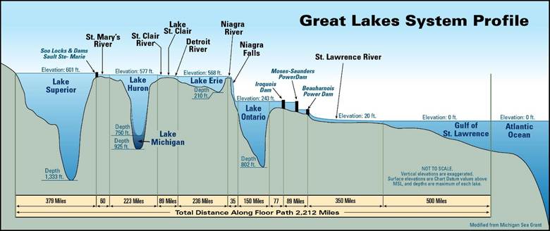
This all aligns with my view that all the great lakes used to drain northwards, except for Lake Ontario. If you look at this map of the Great Lakes’ elevation, you can still see this: Lake Ontario has clearly a far different elevation than all the other lakes – because it is not like the others.
Niagara Falls
The biggest hint that the river connecting Lake Erie to lake Ontario used to not exist – and so this river is very new – is the massive waterfalls on it: Niagara Falls.
Beyond just the waterfall, the Niagara river also has class 6 rapids. Class six rapids are in fact the highest and most dangerous classification on the international river difficulty scale. Accordingly, recreationally rafting on the Niagara river is forbidden.
Here is a picture of the Niagara river gorge:
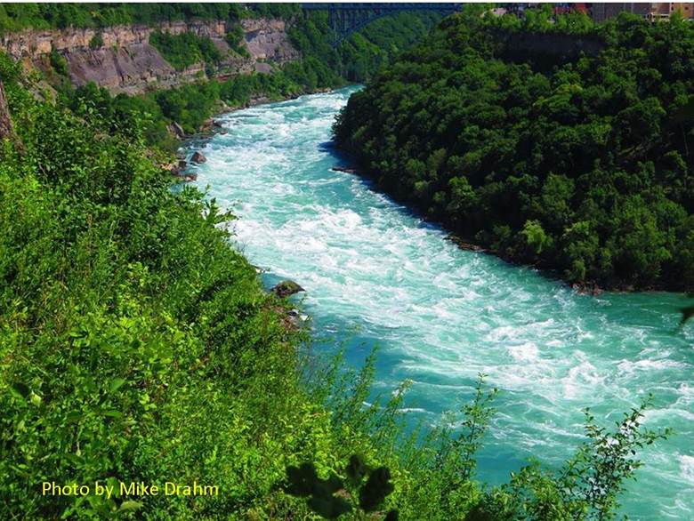
Why do the rapids, the gorge, and the waterfall all matter? Well read this quote from Classifying Rivers – Three Stages of River Development:
“Upon observation of a Youthful River, here is what one might see:
1. The river flowing down a steep gradient (slope).
2. The channel is deeper than it is wide and V-shaped due to downcutting rather than lateral (side-to-side) erosion.
3. Its velocity is fast and strong and …
4. Capable of moving all sediment sizes from ions in solution, to silts and clays, also cobbles and boulders.
5. Steep sided cliffs flank the river.
6. A floodplain does not exist. There are no grassy areas beside the river where a person can walk.
7. Rapids may be present due to the water velocity and the presence of boulders in the channel. Waterfalls are also a feature of a young river.
8. Erosion is prominent over deposition.”
As you can see, the river Niagara has all of the characteristics of a very recently formed river – thus of course aligning with my theory.
Think about it this way: since the rivers connecting each of the great lakes to the next lake are all very short, one should expect that erosion would eventually cause the great lakes to all have nearly the same elevation. It therefore is particularly odd how large the elevation difference is between Lake Ontario and Lake Erie, given that the erosion from just Niagara Falls is immense (it is estimated that Niagara Falls moves back a foot every year due to erosion, and before we diverted water out of the falls for hydro-electric purposes it actually moved back 3 feet each year) … surely this large elevation difference cannot last much longer due to said erosion. Therefore, the fact that all of the great lakes except Ontario have almost exactly the same elevation, but then lake Ontario has a much different elevation, implies the following history: all of the great lakes except lake Ontario either used to literally be connected to each other, or at least drain through each other, thus causing them to have nearly exactly the same elevation. Meanwhile, in the past, lake Ontario was completely separate and drained in a different route – thus causing lake Ontario to have a much different elevation. Therefore, only relatively recent geological events have caused all of the great lakes to connect to each other and drain through the St. Lawrence river.
Conclusions
My belief is that the narrow neck of land leading to the land northward in the Book of Mormon is the area of land between Lake Erie and Lake Ontario. Of course, in today’s geology the description of Nephite wars along this narrow neck wouldn’t make sense in light of the Niagara River. However, I believe that there used to not be a Niagara River, because Lake Erie, Huron, and Superior all used to drain in a different direction that was not through Lake Ontario. Thus, this gap between Lake Erie and Ontario would have been the only practical way to cross into the Ontario region of Canada (the land northward), as all other routes would be blocked by large waterways (beyond going all the way around Lake Superior). This places the homeland of the Nephites in the greater New England area, which explains why the hill Cumorah was in New York.
Consequently, my belief is that the “promised land” of the Book of Mormon is not just the entire American continent, but specifically the territory in which now we find the USA. Thus, we should be aware that all the prophecies and promised blessings and curses associated with the promised land are specifically about us, the residents of the USA.
This geography may also help explain why Noah-like flood stories are concentrated in the eastern United States, a topic I will soon address in future work.
Leave a Reply